

The government has published the names of the 126 French municipalities which will have the obligation to adapt as a priority to coastal erosion aggravated by global warming and human pressure, a list of new urban planning constraints which do not make the unanimity.
With the retreat of the coastline on around a fifth of the French coastline (excluding Guyana) according to the national indicator of coastal erosion, the Climate and Resilience law of 2021 provides for new provisions for municipalities on the front line facing the rise sea level and the increase in storms and sea floods.
The mayors will have to produce maps of the risk of coastal retreat at 30 and 100 years, a map which will serve as the basis for new rules for land use planning, going as far as building bans.
Initially, 126 municipalities are concerned, in mainland France and in the Overseas Territories, according to the list published on Saturday in the Official Journal, which will be revised at least every nine years. The majority are located on the Atlantic and Channel coasts (notably 41 in Brittany, 16 in Normandy, 31 in New Aquitaine).
"These 126 so-called priorities are ridiculous compared to the 864 municipalities threatened", regrets to AFP Elodie Martinie-Cousty, of the NGO France Nature Environnement.
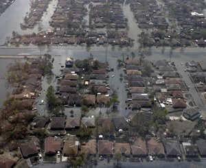
According to official figures, 864 municipalities are "more particularly vulnerable" to marine flooding, phenomena of temporary flooding of coastal areas by the sea, especially during storms, which will increase with the rise in sea level caused by global warming. . And 1,5 million people live in these coastal floodplains.
But "we let too much build on the coast" and the new provisions "are not adapted to the challenges", considers Elodie Martinie-Cousty.
Those of the 126 municipalities that do not yet have a "coastal risk prevention plan" will have to carry out the mapping of the evolution of the coastline at 30 and 100 years.
"It interested me to know the points of vulnerability of the municipality and to be able to say to the population + attention we are in very sensitive areas +", comments the mayor of Trégastel (Côtes d'Armor) Xavier Martin, welcoming the financing by the State 80% of the cost of these maps which he sees as a tool for "anticipating risk".
"If we say that we are renovating (the city centre) and that in 20 years it will be under water, is it useful to renovate it today, should we not think to see it differently?" he told AFP.
Relocations?
In areas exposed to the 30-year horizon, new construction will be prohibited, but with exceptions for the extension of existing buildings or the installation of public services and new economic activities requiring "immediate proximity" to the sea .
The zones over the 100-year horizon remain constructible, with an obligation to demolish in the long term when the threat approaches.
To enable local authorities to launch this new land development, an ordinance published at the beginning of April specifies the means of acquisition by the public authorities of threatened property and creates a new type of lease granted by the State or the municipalities for land, commercial premises or leisure parks in the band concerned (lease from 12 to 99 years with early termination depending on erosion).
But the National Association of Coastal Elected Officials regrets certain "legal vagueness" which "suggests many disputes, likely to harm the achievement of the stated objectives".
Some local officials are also wondering about the new constraints imposed on local urban development plans and are pointing the finger at funding issues.
"The progress that results (from inclusion on the list) remains mainly at the level of raising awareness of the risk", estimates Vincent Bawedin, in charge of the management of the coastline at the Community of municipalities of the Great Lakes, which includes the coastal town of Biscarosse (Landes). He is concerned about financing the relocation of endangered properties.
"Questions arise about who supports the displacement of the population of the affected dwellings", adds Pascal Laporte, assistant for town planning in Plérin (Côtes d'Armor), also noting the problem of "depreciation of property" in the threatened band.
Selection of products


To read also
-
 Climate change: these architects who have decided to stop building
-
 With climate change, goods more difficult to insure
-
 70 countries commit to reviewing ways of building on the planet
-
 Preventing and compensating natural disasters will require more resources, according to the public reinsurer
-
 Coastal municipalities in search of solutions to the decline of the coastline
-
 Accelerate technological and financial innovation to stop global warming
-
 Once again, thousands of French people died from the heat during the summer of 2023
-
 Warming of 4°C expected in France: the adaptation project is changing dimensions